
Flood and Infrastructure Risk
Floods continue to rank among the most costly natural hazards worldwide, affecting communities and economies across all regions. Our research focuses on developing, enhancing, and applying advanced numerical models capable of accurately and efficiently simulating flood events triggered by extreme weather, storm surges, and other drivers. Beyond capturing the dynamics of flooding itself, we aim to assess risks to critical infrastructure, identify vulnerable areas, and provide decision-makers with actionable insights that support preparedness, resilience, and long-term adaptation strategies.
Models involved: RIFT, Telemac-2D/3D, TRITON, ATS, and FEMA-defined Numerical Models Meeting the Minimum Requirements of the National Flood Insurance Program

Watershed Hydrologic and Biogeochemical Functions
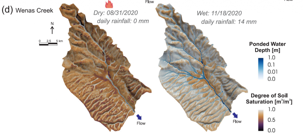
Ecosystem disturbances such as wildfires are dynamic processes that continually alter watershed functions, including but not limited to hydrology, ecology, sediment transport, and water quality. To better understand these changes, we apply state-of-the-art numerical models to evaluate both short- and long-term impacts. Models also play a key role in informing and guiding the development of mitigation strategies, helping to protect ecosystems, water resources, and communities affected by such disturbances.
Models involved: ATS-PFLOTRAN, DHSVM, VIC, MODFLOW, …
Li, Z., Li, B., Jiang, P., Hammond, G. E., Shuai, P., Zahura, F. T., … & Chen, X. (2025). Evaluating Post-fire watershed response to varying burn severity and precipitation regimes using fully-distributed and integrated hydrologic models. Journal of Hydrology. DOI: https://doi.org/10.1016/j.jhydrol.2025.134538
Zahura, F. T., Bisht, G., Li, Z., McKnight, S., & Chen, X. (2024). Impact of topography and climate on post-fire vegetation recovery across different burn severity and land cover types through random forest. Ecological Informatics. DOI: https://doi.org/10.1016/j.ecoinf.2024.102757
Wildfires significantly disturb ecosystems by altering forest structure, vegetation ecophysiology, and soil properties. Understanding the complex interactions between topographic and climatic conditions in post-wildfire recovery is crucial. This study investigates the interplay between topography, climate, burn severity, and years after fire on vegetation recovery across dominant land cover types (evergreen forest, shrubs, and grassland) in the Pacific Northwest region. Using Moderate Resolution Imaging Spectroradiometer (MODIS) data, we estimated vegetation recovery by calculating the incremental Enhanced Vegetation Index (EVI) change during post-fire years. A machine learning algorithm, random forest (RF), was employed to map relationships between the input features (elevation, slope, aspect, precipitation, temperature, burn severity, and years after fire) and the target (incremental EVI recovery) for each land cover type. Variable importance analysis and partial dependence plots were generated to understand the influence of individual features. The observed and predicted incremental EVI values showed good matches, with values of 0.99 for training and 0.89–0.945 for testing. The study found that climate variables, specifically precipitation and temperature, were the most important features overall, while elevation played the most significant role among the topographic factors. Partial dependence plots revealed that lower precipitation tended to cause a reduction in vegetation recovery for varying temperature ranges across land cover types. These findings can aid in developing targeted strategies for post-wildfire forest management, considering the varying responses of different land cover types to topographic, climatic, and burn severity factors.

Turbulence in Open-Channel Flows
Turbulence in open-channel flow holds fascination and great practical importance. — Rodi
Turbulent transport of momentum, heat and mass dominates many of the fluid flows investigated in physics, fluid mechanics, hydraulic engineering and environmental sciences. — Nezu & Nakagawa
At engineering scales, channel roughness provides a practical proxy for representing energy loss within the boundary layer. However, as we zoom into smaller scales, flow dynamics become far more complex. Our research explores how turbulent flow interacts with riverbeds, riverbanks, sediments, and vegetation, as well as the diverse materials that river water comes into contact with or carries downstream. By investigating these multiscale interactions, we aim to provide deeper insights into the processes that shape channel morphology and transport nutrients/pollutants.
Models involved: OpenFOAM, Telemac-3D, Delft3D, EFDC, …
Li, Z., Langendoen, E. J., & García, M. H. (2025). Unveiling the stochasticity of bank erosion: A hybrid deterministic and stochastic modeling approach. Water Resources Research. DOI: https://doi.org/10.1029/2024WR039336


River Dynamics and Fluvial Geomorphology
Rivers are not static features. They continuously evolve unless constrained by geological formations or human interventions. In some cases, channels can shift by over 200 meters in a single year. Using the 1D, 2D, and 3D models we develop or apply to simulate river flow, sediment transport, bed evolution, and bank erosion, we are equipped to capture the full range of spatiotemporal dynamics in river systems.
Models involved: pyRiverBed, Telemac-2D/3D, Delft3D, …
Sun, Y., Song, X., Li, Z., Xu, H., & Bai, Y. (2025). Analytical simulation of meander morphology from equilibrium to long-term evolution: Impacts of channel geometry and vegetation-induced coarsening. International Journal of Sediment Research. DOI: https://doi.org/10.1016/j.ijsrc.2025.02.003
This study introduces an innovative approach to modeling meandering river morphology, integrating and investigating the effects of geometric characteristics and vegetation-induced channel coarsening. The developed comprehensive framework combines several advanced techniques: Genetic Programming for refining the scour factor of transverse bed slope, a Leaf Area Index (LAI)-enhanced analytical model for quantifying vegetative flow resistance, and an upstream-weighted moving average method for efficient approximation of the convolution integral in meander migration calculations. The model is validated against both an idealized Kinoshita meander and a natural bend of the Tumen River (China) in equilibrium, demonstrating its robustness across diverse scales and conditions. The model’s ability to simulate the long-term evolution, including cutoff events, provides valuable insight for river management strategies. The current findings demonstrate that channel geometry, particularly width-to-depth ratio, plays a dominant role in meander evolution, with wider channels prone to more complex and rapid morphological changes. Vegetation effects are most pronounced in channels with moderate width-to-depth ratios, where they can significantly influence migration rates and bed topography. A combination of channel widening and deepening, coupled with strategic vegetation management, can effectively enhance navigability while maintaining channel stability in the studied Tumen River reach. Sensitivity analyses highlight the complex interplay between hydraulic conditions, sediment characteristics, and vegetation in shaping river morphology. This research advances understanding of the multifaceted nature of meandering river systems and offers practical tools for informed decision-making in river engineering and environmental management, particularly in the context of climate change and increasing anthropogenic pressures on fluvial ecosystems.
Li, Z., Mendoza, A., Abad, J. D., Endreny, T. A., Han, B., Carrisoza, E., & Dominguez, R. (2023). High-resolution modeling of meander neck cutoffs: laboratory and field scales. Frontiers in Earth Science. DOI: https://doi.org/10.3389/feart.2023.1208782
Meandering rivers are distinguished by their characteristic sinuosity, which is subject to modulation through channel cutoff, resulting in the formation of oxbow lakes within the abandoned meander loops. Throughout the evolutionary course of a river, these cutoffs establish a connection between the channel and floodplain systems, both crucial to maintaining the dynamic equilibrium of the river system. Nonetheless, the interactive dynamic between the channel and floodplain and its influence on the transient behavior of the channel’s morphodynamics during a cutoff event are frequently reduced to simplistic representations in computational models. This study introduces a comprehensive numerical model that elucidates the adaptive processes of bed and planform during and subsequent to the inception of cutoff and oxbow lakes. The model is assessed through its application to a laboratory scale cutoff, before being employed to a real-world meandering river, specifically the Ucayali River in Peru, in order to gain understanding into channel development and the intricate patterns of planform dynamics following cutoff events. The model is able to capture the main modes of planform migration, translation and expansion for the case of the bend in the Ucayali River. During the neck cutoff, the model simulates the progression of erosional and depositional waves traveling in upstream and downstream directions respectively, underscoring the importance of incorporating both hydrodynamic and morphodynamic factors in characterizing the river dynamics associated with meander cutoffs.
Li, Z., & García, M. H. (2021). pyRiverBed: A Python framework to generate synthetic riverbed topography for constant-width meandering rivers. Computers & Geosciences. DOI: https://doi.org/10.1016/j.cageo.2021.104755
Meandering is one of the unique processes in Earth surface dynamics. Since the 1960s, fluvial geomorphologists have generalized numerous widely-acknowledged empirical or semi-empirical formulae to describe meandering rivers’ characteristics. The most frequently applied one is the Kinoshita high-sinuosity curve to describe meander channel planform geometry. Combining the Kinoshita curve with the Beck equations to describe the riverbed topography at equilibrium state, a prototype of a synthetic riverbed topography generating model is made for idealized meandering rivers. Such a method can be readily extended and applied to arbitrary meandering rivers in the real world, resulting in the synthetic riverbed topography model, pyRiverBed, presented herein. A meander migration and neck cutoff submodel is also embedded in pyRiverBed. Unlike existing linear and non-linear bend theory-based models, pyRiverbed aims towards generating the riverbed topography for each snapshot during the migration process. The present model can facilitate meandering river researchers to interpolate their field-measured bathymetric data using the synthetic bed, design their non-flat bed laboratory flumes for experiments, and initialize their hydrodynamic and morphodynamic numerical models. It can also provide guidance in stream restoration projects on designing a channel with a morphodynamic equilibrium bed. The quality of generated synthetic bed topography is evaluated through the comparison against both laboratory experiment data and field-measured data. The meander migration submodel is validated using a real-world channel migration and neck cutoff event. The validation results prove that the synthetic riverbed’s accuracy is reasonably good, and the meander migration submodel can successfully predict meander migration and neck cutoff.